Map Of Bermuda
On this page you will find every map worth having for a trip to Bermuda: an island overview, the nine parishes, the beaches, the hotels, the towns of Hamilton and St George, and the cruise port at Dockyard. If you are planning a visit and trying to figure out what sits where, this is the page to start with.
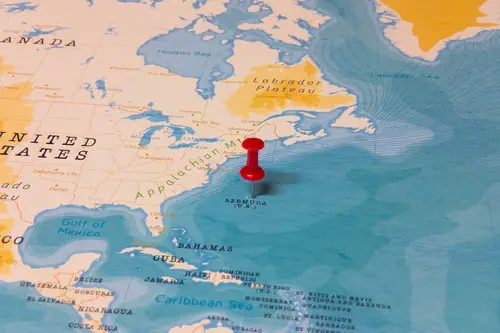
Bermuda Location Map
Bermuda sits in the North Atlantic, about 650 miles east of Cape Hatteras, North Carolina. It is not in the Caribbean, despite the common misconception. The nearest major US cities by air are New York, Boston, Washington, Philadelphia and Charlotte.
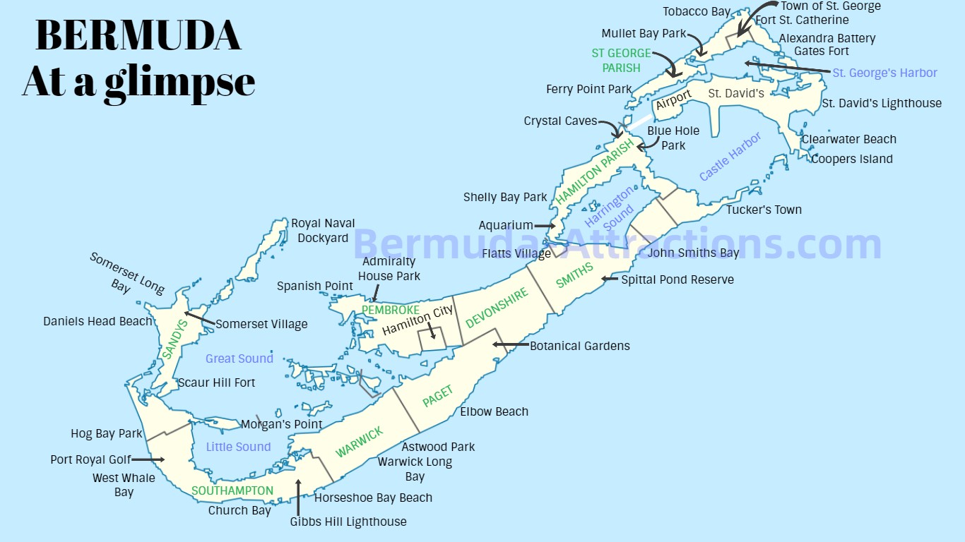
Bermuda Map: All sites at a glance
The following map gives you a snapshot of all the important places and attractions in Bermuda and where they are located. The section below the map gives you parish-wise links to all places shown in the map to get detailed information.
Bermuda Map (Click/Tap for the full size)
The Attractions, Parishes, and Landmarks on Bermuda Map
|
Sandys Parish
|
|
Southampton Parish
|
|
Warwick Parish
|
|
Paget Parish
|
|
Pembroke Parish
|
|
Devonshire Parish
|
|
Smith's Parish
|
|
Hamilton Parish
|
|
St. George's Parish
1) Town of St. George, 2) Airport, 3) Ferry Point Park, 4) Fort St. Catherine, 5) Tobacco Bay, 6) Alexandra Battery, 7) Gates Fort, 8) St. David's, 9) St. Davids Lighthouse, 10) Clearwater Beach, 11) Coopers Island, 12) Tucker's Town, 13) St. George's Parish
|
Interactive Bermuda Map
Below is an interactive map of Bermuda showing the main places/landmarks of the island with colored markers including Royal Naval Dockyard (Kings Wharf Port) located at the western tip in Ireland Island, the South Shore Park which is famous for its several pink sandy beaches (including Horseshoe Bay and Warwick Long Bay), Hamilton City (Capital of Bermuda) which is located centrally.
At the Eastern end is St. George's Town which is a UNESCO World Heritage Site and the former capital of the island. Bermuda's airport is also located at the eastern part in St. David's island.
Interactive Map of Bermuda
How to Use the Map?
Zoom in or out the map to suit your visibility.
When you click or tap a marker on the map, you will see description of the place and understand its significance. In a mobile, you need to scroll up to see the description.
When you expand the map, you will see most of the roads and landmarks including many tourist attractions of Bermuda.
Bermuda Maps by Topic
Beyond the island overview above, I keep a set of specialty maps for the things visitors most often plan around: which parish, which beach, which hotel, where to eat, where to shop, and where the cruise ships dock. Each one focuses on a single topic so you can find what you need without scanning the whole island.
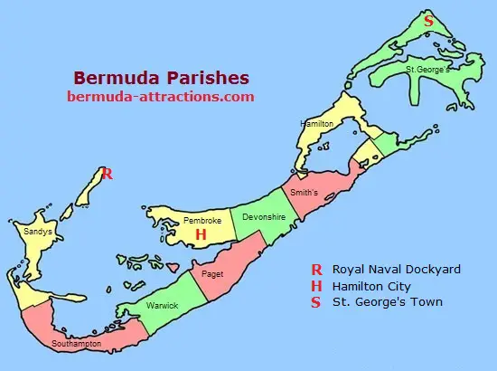
Interactive Map of Bermuda Parishes
Below is a simple interactive map of Bermuda showing all its parishes (or districts). Bermuda is divided into nine parishes.
Parish Map
Click on a parish and see its detailed map
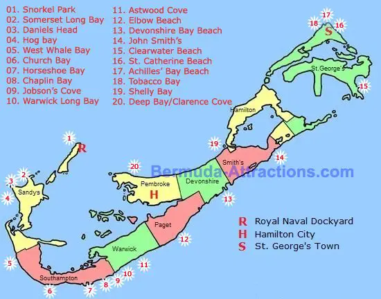
Interactive Map of Bermuda Beaches
We have been die hard fans of the Bermuda beaches. This actually prompted me to create a separate Bermuda beach map showing the location of the beaches. The idea was to have a quick location reference for our favorite Bermuda beaches. Click or tap on a circled beach number and you will see all the details about the beach including some nice pictures.
Click a beach# on the map to get its details
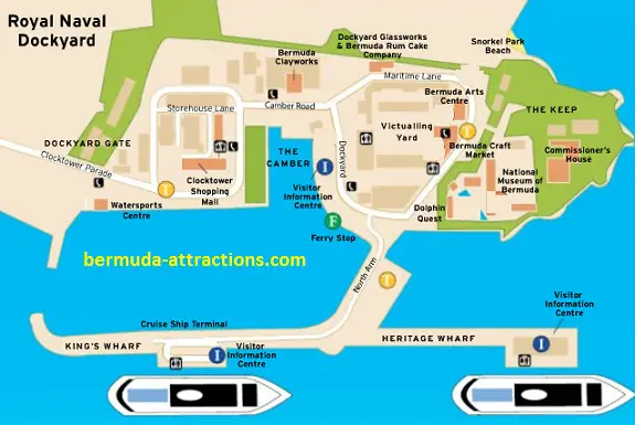
Map of Royal Naval Dockyard (Kings Wharf Port)
This is a map of the dockyard complex which not only has two berths (Kings Wharf and Heritage Wharf) where the cruise ships dock, but is also a great tourist attraction itself with many historical buildings, fortifications, museums, parks, shops and more.
Map of Hamilton City Bermuda
This is a separate map where you can see all the main roads of Hamilton City including the Front Street, Church Street, Queen Street, Reid Street, Victoria Street and others, all in a single image. It also shows the Hamilton Ferry Terminal, Cruise Ship Berths, and a few other landmarks. This should give you a fairly good idea of Hamilton City's layout.
Below the image map, you will also find an interactive map of Hamilton City. You can zoom that and discover many landmarks, attractions and get directions.
Map of St George Bermuda
This is another separate image map of the Town of St. George, Bermuda. Like Hamilton City Map, this one also shows you the major streets in St. George such as Water Street, Duke of Yourk Street, Etc. It also shows major landmarks and attractions of St. George such as the Cruise Port, Ordance Island, St. Peter's Church. Somer's Garden, and more.
Bermuda Hotel Map
I keep a separate Bermuda hotel map that shows where the major hotels and resorts sit across the island, by parish. It is useful for planning your stay around a specific beach, the cruise port at Dockyard, the city of Hamilton, or the airport.
Each hotel on the map is numbered and matched to a list with a link to the property details. See the
Bermuda Hotel Map
Bermuda Dining Map
This shows locations of various popular restaurants across Bermuda, by parish. Each restaurant on the map is numbered and matched to a list below with a link to the restaurant details. Hamilton and St. George's restaurants are shown in separate maps.
Hamilton Dining Map
This is a separate map similar to the Bermuda Dining Map, but showing restaurants only in Hamilton City. This too has a list of links matching the numbered restaurants on the map.
St George Dining Map
This map shows the location of the best restaurants in the Town of St George, Bermuda. Like the map above, this too shows restaurants with marked numbers followed by a matching list of linked restaurant details.
Bermuda shipwreck map
In my section on
Bermuda Shipwrecks, I have discussed all the famous shipwrecks around Bermuda and what you can expect to see if you are planning for a scuba dive in Bermuda's water. This map will give you an idea about where these shipwrecks are in the Atlantic with respect to the island.
About the Author
 By Raj Bhattacharya
Raj has been writing about Bermuda since 2008, when he launched bermuda-attractions.com, one of the longest-standing independent guides to the island. A Certified Bermuda Specialist (Bermuda Tourism Authority), his work draws on personal visits, local contacts in Bermuda, and questions and trip reports from thousands of readers over the years.