Where is Bermuda Located on the Map?
If you are looking at a world map for the first time and trying to find Bermuda, you will probably miss it. Bermuda shows up as a single tiny dot sitting alone in the open North Atlantic, with no chain of islands leading up to it and no other land close enough to help you place it at a glance. That isolation is exactly what makes its location so unusual, and it explains a lot about how the island feels when you actually visit.
I get questions about Bermuda's location almost every week from readers planning their first trip. Many assume Bermuda is somewhere in the Caribbean. Others think it belongs to the United States. Neither is correct. So let me walk you through exactly where Bermuda sits, how far it is from places you already know, and a few other things that often confuse first-time travelers.
Location of Bermuda on Map
Where Exactly is Bermuda?
Bermuda sits in the western North Atlantic Ocean, roughly 650 miles east of the east coast of the United States. The nearest piece of land to Bermuda is Cape Hatteras in North Carolina, and the stretch of open ocean between them is about 640 to 650 miles wide (around 1,030 to 1,050 kilometers). Charleston, South Carolina lies about 883 miles to the west, and New York City is about 775 miles to the northwest.
The geographic coordinates of Hamilton, the capital, are 32.2948 degrees North and 64.7814 degrees West. If you drop those numbers into Google Maps, you will land in the middle of the island. Bermuda lies in the Northern and Western hemispheres, well above the Tropic of Cancer, which is one reason its climate is subtropical rather than tropical like the Caribbean.
Looking further out, Bermuda's nearest inhabited neighbors are surprisingly far away. The Azores, a group of Portuguese islands in the mid-Atlantic, lie about 2,000 miles to the east. Halifax in Nova Scotia, Canada, sits about 760 miles to the north-northwest.
The Bahamas lie roughly 950 miles to the south-southwest, and Puerto Rico is around 980 miles to the south. In every direction, you are looking at hundreds of miles of open ocean before you hit land, which is part of what makes Bermuda's position on the map so striking.
Bermuda is not a single island. It is an archipelago of about 181 islands, islets and rocks. Eight of the larger islands are linked together by bridges and one causeway, and that connected stretch is what locals and visitors usually refer to as the mainland. About twenty of the islands have people living on them.
The total land area is only around 21 square miles (about 54 square kilometers), and from end to end the connected mainland stretches roughly about 24 miles, with a maximum width of less than two miles. The shape, as you will see on any
detailed map of Bermuda, looks a lot like a fishhook with the curve at the south-west end.
Bermuda Location Map (with flight duration)
Is Bermuda Part of the United States?
No, Bermuda is not part of the United States. This is one of the most common questions I get, and I understand the confusion. Bermuda sits closer to the US than to any other country, the US dollar is accepted everywhere on the island, most tourists are American, and many businesses look and feel familiar to American visitors. None of that makes it part of the US.
Bermuda is a British Overseas Territory. It has been under British control since 1612 and is in fact the oldest continuously inhabited British Overseas Territory in the world, settled by English forces almost a century before the Acts of Union created the Kingdom of Great Britain. It is self-governing on most internal matters, but defense, foreign affairs and internal security remain the responsibility of the United Kingdom.
The head of state is King Charles III, who is represented locally by a Governor appointed by the King on the advice of the British Prime Minister. The current Governor, Andrew Murdoch, was sworn in on January 23, 2025. Day to day government is run by the Premier, who is the leader of the majority party in the elected House of Assembly.
Edward David Burt has held that position since July 2017 and was returned to office in the general election of February 2025. So you are dealing with a place that uses British constitutional structures, has its own parliament, prints its own currency (the Bermudian dollar, pegged one to one with the US dollar), and has its own laws, courts and immigration rules.
If you are an American citizen visiting, you still need a passport to enter and to return home. Bermuda is foreign soil for customs and immigration purposes, even though it feels close to home in many other ways.
📖 Planning a trip to Bermuda?
Get our practical Bermuda travel guides with insider tips and ready-to-use planning insights.
View Guides
Used by thousands of travelers planning Bermuda trip
Is Bermuda in the Caribbean?
Also no. This one trips up almost as many people as the US question. Bermuda is in the North Atlantic, well north of the Caribbean Sea. The nearest Caribbean island lies more than 800 miles away to the south, and there is nothing but open ocean between them.
The mix-up usually comes down to the look of the place. Bermuda has pink sand beaches, palm trees, turquoise water and a relaxed island pace, all of which make people think Caribbean. But geographically and culturally, Bermuda sits on its own.
Its winter is cooler than the Caribbean, its hurricane patterns behave a little differently, and the architecture, accents and traditions reflect a British heritage with strong American influence rather than a Caribbean one. You can read more about all of this on my page on
about Bermuda.
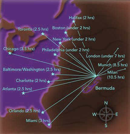
Bermuda on the Map: Distance from Major Cities
Here is how far Bermuda is from some of the cities that send the most visitors. These are straight-line air distances and approximate nonstop flight times.
From New York: about 760, roughly 2 hours 15 minutes by air.
From Boston: about 770 miles, just over 2 hours.
From Washington DC, Atlanta and Orlando: around 2 hours 30 minutes.
From Miami: about 1,038 miles, roughly 2 hours 40 minutes.
From Toronto: about 1,123 miles, about 2 hours 50 minutes nonstop.
From London Heathrow: about 3,471 miles, around 7 hours 30 minutes going west, slightly less coming back with tailwinds.
From Munich: about 4,053 miles, around 8.5 hours including a connection.
From Milan: about 10 to 10.5 hours including a connection.
If you are coming from continental Europe, Africa or Asia, you will almost always route through London, New York or Toronto. Bermuda is served by a single airport, L. F. Wade International (airport code BDA), on the eastern end of the island. For full details on routes, airlines and seasonal services, see my page on
air travel to Bermuda.
Photo: Bermuda Tourism Authority
Why Bermuda's Location Matters
Bermuda's position is not just trivia. It shapes a lot of practical things about visiting and about life on the island.
First, the short flight from the US east coast makes Bermuda one of the few foreign destinations where you can be on a pink sand beach less than three hours after leaving home. That is why it is so popular as a long-weekend getaway from cities like New York, Boston and Philadelphia.
Second, Bermuda's mid-Atlantic position gives it a milder climate than the Caribbean. Summer water and air temperatures are warm, but winter is cool. From December through March, you will often see daytime highs in the 60s Fahrenheit, which is too cool for swimming for most people but pleasant for walking, golfing and sightseeing.
Third, the same isolated position that makes Bermuda feel remote also helped make it one of the world's leading offshore financial centers. Bermuda sits at a useful midpoint between Europe and North America, with a stable government and British legal traditions, which is why so many international insurance, reinsurance and investment firms have a base here.
Bermuda's Place in the So-called Bermuda Triangle
If you grew up hearing about the Bermuda Triangle, you may be wondering how that fits with the location I have described. Bermuda forms the northeastern corner of an imaginary triangle in the North Atlantic. The two other corners are usually placed at San Juan in Puerto Rico, about 980 miles south of Bermuda, and Miami in Florida, about 1,034 miles to the southwest. None of the three corners is officially designated.
The triangle has no agreed boundaries, no recognition from the US Board on Geographic Names or the US Navy, and most modern investigations have concluded that the rate of incidents in this stretch of ocean is in line with any other busy shipping and flying lane.
I have looked into the alleged disappearances and the various theories at length on a separate page. If the subject interests you, see my full write-up on
Bermuda Triangle facts and myths. For the purposes of this page, just know that you can fly to Bermuda or sail to it on a cruise ship with the same level of safety as any other Atlantic crossing. Over 650,000 visitors a year do exactly that.
Bermuda's Time Zone
Bermuda follows Atlantic Standard Time, which is one hour ahead of US Eastern Time. So when it is noon in New York, it is 1 pm in Hamilton. Bermuda also observes daylight saving time on the same schedule as the United States, so that one-hour gap is consistent throughout the year. For full details and the current local time on the island, see my page on
Bermuda's time zone.
Geography of the Island Itself
Bermuda is volcanic in origin. The base of the island is the eroded summit of an extinct volcano that rose from the seabed roughly 100 million years ago. Everything from the seabed up to about 200 feet below the present water surface is volcanic rock. The visible part of the island, the part you walk on, is limestone made from compacted seashells and coral over millions of years.
There are no rivers and no fresh water lakes in Bermuda. Drinking water comes from rainfall, which is caught on the famously white stepped roofs of Bermuda houses and stored in tanks beneath each home. The highest point on the island is Town Hill in
Smiths Parish, which reaches only 259 feet (79 meters) above sea level. There are no mountains in Bermuda.
The country is divided administratively into nine parishes.
Hamilton City, the capital, sits centrally in Pembroke parish. The
Town of St. George, a UNESCO World Heritage Site and the first English settlement on the island, is at the east end. The
Royal Naval Dockyard, the main cruise port, sits at the west end on Ireland Island.
Bermuda Aerial View
Photo: PH1 Doolittle, USN, CC
How to Reach Bermuda from Where You Are
The only practical ways to get to Bermuda are by air or by sea. There are no ferries from the mainland and no road or rail connections, for the obvious reason that there are hundreds of miles of open ocean between Bermuda and anywhere else.
By air, you fly into L. F. Wade International Airport on St. David's Island at the east end of Bermuda. Direct flights operate from New York (JFK and LGA), Newark, Boston, Philadelphia, Washington Dulles, Atlanta, Miami, Charlotte, Toronto and London Heathrow.
Carriers serving the route include American Airlines, Delta, JetBlue, United, Air Canada, BermudAir and British Airways. Schedules expand in the summer high season and contract in winter, so always check current schedules when planning. See my page on
Flights to Bermuda to get current flight information and schedules.
By sea, several cruise lines including Norwegian, Royal Caribbean and Carnival run regular sailings from New York, Boston, Baltimore and a few other east coast ports during the May to October season. A typical seven-night round-trip cruise from New York gives you about two and a half days docked in Bermuda. Ships dock either at the Royal Naval Dockyard, in Hamilton, or occasionally in St. George. For full details see my
cruise guide to Bermuda.
Quick Location Facts at a Glance
For readers who want the short version, here is Bermuda's location in summary.
Bermuda is a British Overseas Territory in the western North Atlantic Ocean. It lies about 640 to 650 miles east of Cape Hatteras, North Carolina, and about 775 miles southeast of New York City. It is not part of the United States and not part of the Caribbean. It is an archipelago of around 181 islands covering 21 square miles in total, with eight main islands connected by bridges.
The capital is Hamilton, at coordinates 32.2948 N, 64.7814 W. The highest point is Town Hill at 259 feet (79 meters). The local time zone is Atlantic Standard Time, one hour ahead of New York. The currency is the Bermudian dollar, pegged to the US dollar. The head of government is the Premier; the head of state is King Charles III, represented by a Governor.
That is everything you need to place Bermuda on a map and understand what you are looking at when you do. If you want to dive deeper into the island itself, its history, its people and the practical side of planning a trip, start with my page on
about Bermuda and work outward from there.
About the Author
 By Raj Bhattacharya
Raj has been writing about Bermuda since 2008, when he launched bermuda-attractions.com, one of the longest-standing independent guides to the island. A Certified Bermuda Specialist (Bermuda Tourism Authority), his work draws on personal visits, local contacts in Bermuda, and questions and trip reports from thousands of readers over the years.
Related Articles